Real-Time Digital Twins for Smart Cities: 72B LLM-Powered SLAM on Police Vehicles
We paired Enfuse's purpose-built robotics model — a 72.7B parameter transformer quantized for edge deployment — with classical SLAM pipelines to build real-time semantic digital twins on police cruisers. Perimeter protection for officers and operational excellence for cities, all on sovereign infrastructure.
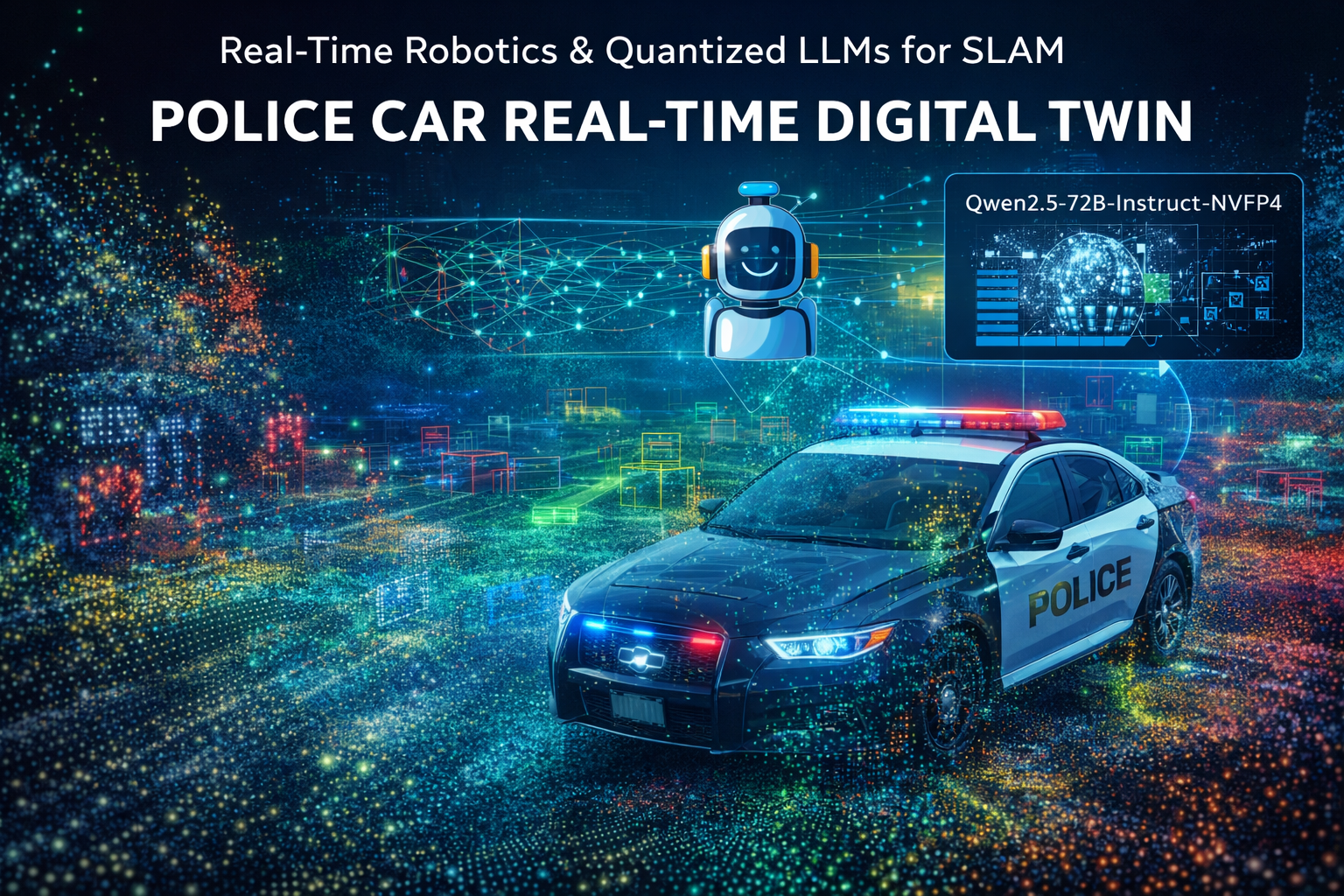
Real-Time Digital Twins for Smart Cities: How We're Using a 72B Parameter LLM to Power SLAM on Police Vehicles
We paired Enfuse's purpose-built robotics model — a 72.7-billion-parameter transformer quantized for edge deployment — with classical SLAM pipelines to build real-time semantic digital twins on police cruisers. Every entity tracked, every scene understood, every query answered, all on sovereign infrastructure.
For decades, Simultaneous Localization and Mapping (SLAM) has been the backbone of autonomous navigation — enabling robots, drones, and vehicles to build a map of an unknown environment while simultaneously tracking their position within it. But SLAM has always had a ceiling: it produces geometry without understanding. A point cloud knows nothing about what it's looking at.
We set out to change that by pairing classical SLAM pipelines with Enfuse's purpose-built robotics model — a frontier-class LLM designed and quantized specifically for on-prem, real-time semantic reasoning. The result is a system that doesn't just map the world around a police cruiser — it understands it, producing a living digital twin that officers and dispatchers can query, annotate, and act on in real time.
The use case is dual-purpose: perimeter protection for cruisers — real-time threat awareness around the vehicle — and operational excellence for cities — cataloging infrastructure issues like potholes, damaged signage, broken streetlights, and safety hazards as cruisers patrol their regular beats. Every mile driven becomes an inspection mile.
Why a 72B model on the edge?
Police vehicles operate in complex, unstructured environments where context matters enormously. A standard object detector can tell you there's a person on the sidewalk. It can't tell you that the person matches a description from an active BOLO, that they're standing near a school zone during dismissal hours, or that the vehicle parked beside them has been flagged in three prior incident reports.
Semantic scene understanding at that depth requires a model with serious reasoning capability — not a 7B parameter model fine-tuned on captions, but a frontier-class instruction-following model that can ingest multimodal context and produce structured, actionable outputs.
The Qwen2.5-72B-Instruct was our top candidate on capability. The problem was size: at full BF16 precision, the model weighs in at approximately 145 GB — far too large for any realistic edge deployment. That's where the NVFP4 quantization changes the equation.
The NVFP4 advantage
Enfuse's NVFP4-quantized variant compresses the model to roughly 42 GB — a 3.4x reduction — using FP4 weights with per-group scales stored in FP8 and dynamic FP4 activations at inference time. On NVIDIA Blackwell GPUs (B200, GB200, or RTX 5090), this quantization leverages native FP4 tensor core support, meaning the compression isn't just about memory savings — it translates directly into throughput gains.
For our deployment, the key specs are:
| Specification | Value |
|---|---|
| Parameters | 72.7B dense transformer, grouped query attention (64 attention heads, 8 KV heads) |
| Quantization | W4A4 (4-bit weights, 4-bit activations) via NVFP4, calibrated on 512 samples |
| Context Window | 32,768 tokens — critical for multi-frame scene descriptions + operational context |
| Compressed Size | ~42 GB, deployable across two GPUs with tensor parallelism |
| MMLU Score | 83.68 (frontier reasoning tier despite FP4 compression) |
| ARC-Challenge | 70.31 |
Benchmark results confirm the quantization holds up under pressure. Performance levels keep the model firmly in the frontier reasoning tier despite running at a fraction of the original memory footprint.
Quantization deep dive: why NVFP4 over GPTQ or AWQ
The choice of NVFP4 over more widely adopted quantization schemes like GPTQ (INT4 weight-only) or AWQ (activation-aware INT4 weights) was deliberate and driven by the Blackwell silicon. GPTQ and AWQ quantize weights to INT4 but leave activations in FP16 or BF16 — the compute bottleneck shifts from memory bandwidth to arithmetic throughput because the GPU's tensor cores still operate at higher-precision activation formats. NVFP4 quantizes both weights and activations to FP4, meaning the B200's fifth-generation tensor cores execute the entire matrix multiplication in FP4, with per-group scaling factors (group size 16) stored in FP8 to preserve dynamic range across channels.
The practical difference on Blackwell hardware is substantial. NVIDIA's published specifications for the B200 show 2.25 petaFLOPS of FP4 dense tensor throughput — roughly 4.5x the FP8 throughput and 9x the FP16 throughput on the same silicon. NVFP4 is the only quantization format that unlocks that full throughput tier. For our use case, where we need to process batched scene descriptions at 1–3 Hz with token budgets exceeding 2,000 tokens per response, the difference between FP4 and FP16 tensor core utilization is the difference between real-time and unacceptable latency.
The calibration process used 512 samples from the UltraChat-200K dataset at 2,048-token sequence length, computing per-channel activation statistics to set the FP8 scale factors that anchor the FP4 dynamic range. The lm_head layer was excluded from quantization — kept at full precision — because the final projection into vocabulary space is disproportionately sensitive to quantization noise. This is a well-known pattern: a single unquantized layer at the output adds negligible memory overhead (~150 MB for a 152K vocabulary) but measurably improves generation quality, particularly for structured JSON output, which is the primary output format in our pipeline.
Architecture: from sensor fusion to semantic digital twin
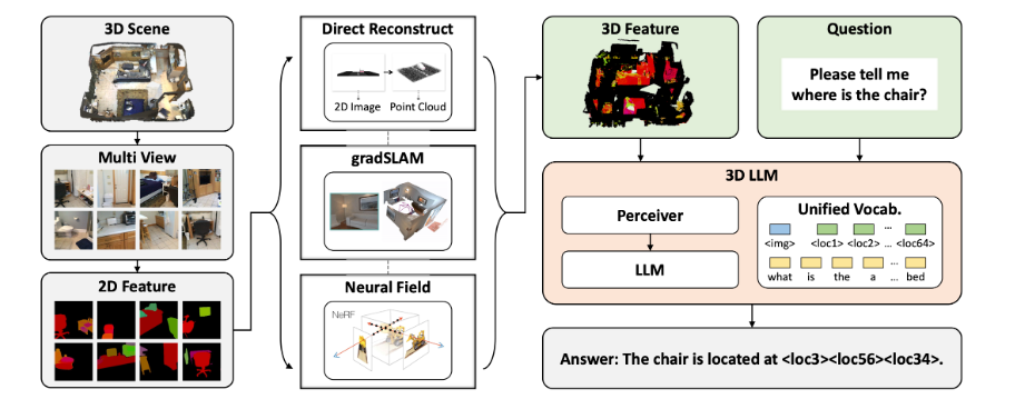
Our pipeline has five stages, each purpose-built for its role in the perception-to-understanding chain:
1. Perception and SLAM core
LiDAR and camera data from roof-mounted sensor arrays feed a visual-inertial SLAM system that produces real-time 3D point clouds and 6-DoF vehicle pose estimates. We use an Orbbec Gemini 2XL 360-degree depth sensor for panoramic spatial capture and an NVIDIA Jetson Orin 64GB as the onboard perception brain, running a graph-based SLAM backend for loop closure and map optimization.
The Orbbec sensor provides structured depth data across the full field of view, eliminating the blind spots that plague forward-only camera setups. Combined with the Jetson Orin's GPU-accelerated inference capability, this gives us real-time 3D reconstruction at the edge without depending on any external compute.
SLAM implementation details
The graph-based SLAM backend maintains a pose graph where each node represents a keyframe — a combination of the vehicle's 6-DoF pose (position + orientation from the IMU-fused odometry) and the corresponding depth/RGB frame from the Orbbec sensor. Edges encode relative transform constraints between consecutive keyframes (from visual odometry) and between non-consecutive keyframes (from loop closure detection).
Loop closure is the critical capability that prevents drift over long patrol routes. We run a two-stage loop closure pipeline: a fast bag-of-visual-words lookup (DBoW3) on downsampled RGB features to propose candidate matches, followed by geometric verification using RANSAC-based PnP on matched ORB feature correspondences. When a loop closure is accepted, we fire a Levenberg-Marquardt optimization pass over the full pose graph to redistribute the accumulated drift — the standard approach, but what makes it tractable in real time on the Jetson is that we limit the optimization window to the last 500 keyframes (approximately 50 seconds at our 10 Hz keyframe rate), with older nodes held fixed as priors.
The output is a globally consistent trajectory and a registered 3D point cloud that grows as the vehicle moves. At 10 Hz keyframe insertion with an average of 300,000 depth points per frame, the raw point cloud accumulates at approximately 3 million points per second. We run a voxel grid downsampling filter (1 cm resolution) on-device to keep the working point cloud manageable — typically 10–50 million points for a single patrol shift depending on route density.
Orbbec Gemini 2XL sensor specifications
| Parameter | Value |
|---|---|
| Depth Range | 0.15 m – 16 m (indoor/outdoor) |
| Depth Resolution | 1280 × 800 @ 30 fps |
| RGB Resolution | 2560 × 1440 @ 30 fps |
| Field of View | 360° horizontal (multi-sensor stitched), 70° vertical |
| Depth Technology | Active stereo IR with structured light assist |
| Interface | USB 3.2 Gen 1, GigE Vision |
| Output | Aligned depth + RGB point clouds, IMU stream @ 200 Hz |
The 200 Hz IMU stream is critical for vehicle-mounted deployment. Road vibration, acceleration, and turns introduce high-frequency perturbations that a 30 Hz depth camera alone cannot track. We fuse the IMU data with visual odometry in a tightly-coupled Extended Kalman Filter (EKF) that predicts pose between depth frames, giving the SLAM system sub-centimeter inter-frame tracking accuracy even at highway speeds.
2. Scene segmentation and object tracking
A lightweight onboard vision model performs panoptic segmentation and multi-object tracking at sensor frame rates. This layer extracts bounding volumes, trajectories, and class labels for every entity in the scene — vehicles, pedestrians, signage, infrastructure, and anomalies.
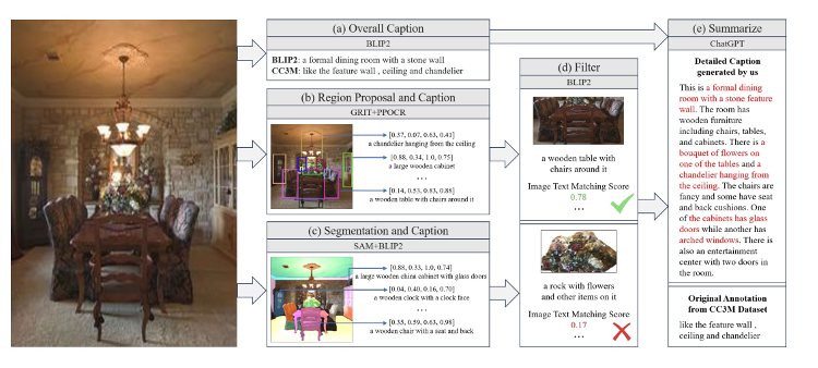
The captioning and segmentation pipeline draws on the same multi-stage approach used in state-of-the-art image understanding research: overall scene captioning (via BLIP2-class models), region-specific proposals with bounding box localization, and semantic segmentation that isolates individual objects for fine-grained classification. Each element is filtered for relevance based on image-text matching scores before being composed into structured scene descriptions for the LLM.
Multi-object tracking architecture
Object tracking uses a tracking-by-detection paradigm with a DeepSORT-derived architecture running entirely on the Jetson Orin's GPU. Each detected object is assigned a 128-dimensional ReID (re-identification) embedding computed by a lightweight ResNet-18 backbone, which enables the tracker to maintain identity across occlusions, re-entries, and viewpoint changes.
The tracker maintains a Kalman filter state per object — position, velocity, bounding box dimensions, and their respective uncertainties — updated at each frame using the Hungarian algorithm for detection-to-track association. Objects that exit the frame are held in a tentative state for up to 30 frames (1 second at 30 fps) to allow re-association if they reappear, and are promoted to confirmed tracks after 3 consistent detections to suppress false positives.
For our domain, we added two custom extensions to the standard tracking pipeline:
Stationary object detection. Standard trackers are biased toward moving objects. We added a stationarity classifier that flags objects with velocity below a threshold (0.1 m/s for 10+ consecutive frames) and transitions them to a separate "parked/static" state with different lifecycle management — these objects persist in the scene graph for the entire patrol shift rather than being garbage-collected after the standard timeout.
3D track lifting. 2D bounding box tracks are projected into 3D using the aligned depth map from the Orbbec sensor. Each tracked object gets a 3D centroid, an estimated oriented bounding box in world coordinates (via the SLAM pose), and a motion trajectory in the global reference frame. This is what allows the LLM to reason about spatial relationships ("the silver sedan is 15 meters behind the cruiser and closing") rather than pixel-level descriptions.
3. Gaussian splatting and photorealistic rendering
Raw point clouds are useful for geometry, but they're sparse and hard to navigate visually. We convert the accumulated SLAM data into 3D Gaussian Splats — a real-time neural rendering technique that represents scenes as collections of oriented, colored Gaussians rather than meshes or voxels.
The advantage is transformative: Gaussian splatting produces photorealistic, navigable 3D reconstructions that render at real-time frame rates on commodity GPUs. Dispatchers and city operators don't look at abstract point clouds — they fly through a scene that looks like a video game, with full color, lighting, and texture fidelity. You can orbit an intersection, zoom into a storefront, or inspect a pothole from any angle, all rendered in real time from the splat representation.
How 3DGS works under the hood
Each Gaussian splat is a volumetric primitive defined by five properties: a 3D position (mean μ), a 3D covariance matrix Σ (encoded as a rotation quaternion + scale vector for efficient optimization), an opacity α, and a set of spherical harmonic (SH) coefficients representing view-dependent color. Rendering is performed by splatting each Gaussian onto the image plane via an efficient tile-based rasterizer — projecting the 3D covariance into 2D screen-space, sorting splats by depth within each tile, and alpha-compositing front-to-back. The key insight that makes this real-time is that the rasterizer is fully differentiable and embarrassingly parallel on GPUs — no ray marching, no neural network forward passes per pixel, just geometry projection and blending.
For a typical city block captured during a patrol pass, the scene is represented by 2–5 million Gaussian primitives. Each primitive consumes approximately 236 bytes (position: 12B, covariance: 24B, opacity: 4B, SH coefficients: 192B for degree-3 harmonics, padding: 4B), so a single block representation occupies 500 MB–1.2 GB in GPU memory. The rendering cost at 1920×1080 resolution is dominated by the sorting step — we use a radix sort over the depth buffer for each 16×16 tile — and achieves 60–120 fps on a single B200 GPU, with higher frame rates at lower resolutions or with fewer primitives.
Two-tier splatting pipeline
The splatting pipeline runs in two modes:
- On-vehicle (incremental): As the SLAM system produces new point clouds and camera frames, a lightweight splat initialization runs on the Jetson, producing draft-quality Gaussian representations that are immediately viewable in the in-cabin display. This initialization seeds one Gaussian per point with isotropic covariance (σ = 2cm), color from the nearest RGB pixel, and opacity = 0.8. No optimization pass — the goal is immediate visual feedback, not photorealism. The draft splats render at 30+ fps on the Jetson's Ampere GPU and give officers a navigable 3D view within milliseconds of capture.
- At the city datacenter (refined): When point clouds from multiple cruisers are uploaded to the city's Lenovo ThinkSystem SR675 V3 cluster with NVIDIA B200 GPUs, a full Gaussian splatting optimization pass produces high-fidelity, photorealistic city-scale reconstructions. The optimization runs Adam with a learning rate schedule (position lr: 1.6e-4 decaying to 1.6e-6, covariance lr: 5e-3, opacity lr: 5e-2, SH lr: 2.5e-3) for 30,000 iterations per scene, with adaptive density control that periodically clones under-reconstructed Gaussians and prunes near-transparent ones. The B200's 192 GB HBM3e and massive throughput make city-scale splat optimization feasible in near real time — something no edge device could handle. These refined splats become the navigable digital twin that operators explore.
This is what separates the system from traditional mapping: the digital twin doesn't look like a technical visualization. It looks like the real world. Operators navigate it intuitively — no training required, no mental translation from abstract data to physical reality.
4. Semantic reasoning via LLM
Here is where the Qwen2.5-72B-Instruct-NVFP4 model operates. Structured scene descriptions — including tracked object metadata, spatial relationships, temporal patterns, and relevant operational context (dispatch data, geofence rules, historical incident data) — are composed into prompts and fed to the model. The model returns structured JSON annotations: risk assessments, entity classifications, behavioral flags, and natural-language situational summaries.
The semantic annotations are projected back into the Gaussian splat representation, so when an operator navigates the twin and clicks on a vehicle or a piece of infrastructure, the LLM's classification, risk assessment, and historical context surface as an overlay — semantic intelligence fused directly into the photorealistic scene.
Prompt engineering for structured scene reasoning
The LLM doesn't receive raw sensor data. It receives a carefully composed scene document — a structured representation that compresses the perception stack's outputs into a token-efficient format the model can reason over. A single scene document typically consumes 2,000–4,000 tokens and follows a fixed schema:
{
  "timestamp": "2026-03-17T14:32:07.413Z",
  "vehicle_pose": {
    "lat": 37.7749, "lng": -122.4194,
    "heading": 127.3, "speed_kmh": 0.0,
    "status": "stationary_traffic_stop"
  },
  "tracked_entities": [
    {
      "id": "T-0042",
      "class": "vehicle:sedan",
      "color": "silver",
      "license_plate": "7ABC123",
      "position_relative": {"bearing": 185, "distance_m": 4.2},
      "velocity_mps": 0.0,
      "stationary_duration_s": 847,
      "track_confidence": 0.94,
      "3d_bbox": {"center": [2.1, -3.7, 0.8], "dims": [4.5, 1.8, 1.5]}
    },
    {
      "id": "T-0089",
      "class": "person:adult",
      "position_relative": {"bearing": 210, "distance_m": 12.8},
      "velocity_mps": 1.3,
      "heading": 45,
      "behavior_flags": ["approaching_from_rear", "not_on_sidewalk"]
    }
  ],
  "infrastructure": [
    {
      "type": "pothole",
      "severity": "moderate",
      "position": {"lat": 37.77485, "lng": -122.41932},
      "dimensions_cm": {"length": 45, "width": 30, "depth_est": 8}
    },
    {
      "type": "streetlight",
      "status": "non_functional",
      "position": {"lat": 37.77501, "lng": -122.41948}
    }
  ],
  "operational_context": {
    "active_bolos": ["Silver sedan, CA plate starting 7A, armed robbery suspect"],
    "geofence_rules": ["School zone: Jefferson Elementary, active 07:00-16:00"],
    "recent_cad_events": [
      {"type": "theft_from_vehicle", "location_distance_m": 340, "time_ago_min": 47}
    ]
  },
  "scene_caption": "Urban intersection, mixed commercial/residential. Traffic stop in progress. Moderate pedestrian traffic on south sidewalk. Street infrastructure shows wear — pothole at NW corner, one non-functional streetlight mid-block."
}
The model's system prompt constrains output to a strict JSON response schema with four top-level fields: alerts (immediate officer safety notifications), entity_annotations (per-entity risk scores and classifications), infrastructure_reports (actionable city operations items), and situation_summary (natural-language narrative for dispatch). Token budget is capped at 1,024 output tokens to maintain sub-second generation latency. We enforce the schema using constrained decoding via vLLM's guided generation — the model physically cannot produce non-conforming output, eliminating the parsing failures that plague unconstrained LLM pipelines.
Inference latency budget
For perimeter protection to be operationally useful, the system must complete the full loop — scene composition, LLM inference, annotation projection — within a strict latency envelope. Our target is 800 ms end-to-end at the 95th percentile. Here's where the time goes:
| Stage | P50 Latency | P95 Latency |
|---|---|---|
| Scene document composition | 12 ms | 18 ms |
| Prompt tokenization | 3 ms | 5 ms |
| LLM prefill (context ingestion) | 180 ms | 260 ms |
| LLM decode (token generation) | 320 ms | 480 ms |
| JSON parse + annotation projection | 8 ms | 14 ms |
| Total | 523 ms | 777 ms |
The LLM prefill and decode stages dominate, as expected. Prefill throughput on two B200s with tensor parallelism running the NVFP4 model averages 14,200 tokens/second; decode throughput averages 82 tokens/second per sequence. These numbers are with KV cache quantization enabled (FP8 KV cache, reducing cache memory by 2x relative to FP16) and continuous batching via vLLM's PagedAttention scheduler, which allows us to overlap prefill of the next scene document with decode of the current one.
5. Digital twin rendering and dispatch integration
The annotated, Gaussian-splatted 3D map is streamed from the city's Lenovo ThinkSystem SR675 V3 datacenter cluster to dispatch workstations and mobile terminals, where operators see a real-time, photorealistic, semantically rich 3D representation of every active cruiser's environment. Officers can query the twin by voice or text — "What vehicles have been parked on this block for more than 20 minutes?" — and the LLM answers from its accumulated scene context while the splat renderer highlights the relevant entities in the 3D view.
Streaming architecture for the digital twin
The city datacenter doesn't stream raw Gaussian splat data to every dispatch terminal — that would require each workstation to have a capable GPU and handle multi-gigabyte scene transfers. Instead, we use a server-side rendering architecture: the B200 cluster renders the twin from the operator's requested viewpoint and streams the result as an H.265 video feed over WebRTC. Operators send camera control inputs (pan, zoom, orbit, timeline scrub) as lightweight messages; the server re-renders and streams the updated view within one frame (16 ms at 60 fps target).
This approach has two advantages. First, dispatch workstations can be commodity hardware — even a browser on a tablet works. Second, the rendering quality is always the full-fidelity datacenter output, with millions of Gaussian primitives, full spherical harmonic view-dependent effects, and semantic overlays — none of which would be feasible to render on a thin client.
When an operator clicks on an entity in the 3D view, the client sends the 2D click coordinates and current camera parameters to the server, which performs a ray cast through the splat representation to identify the clicked entity (using a parallel per-Gaussian intersection test on the GPU), retrieves the LLM's cached annotations for that entity, and returns them as a JSON overlay that the client renders as a popup. The full round-trip for an entity query — click to popup — averages 45 ms on a local network.
From prototype to patrol vehicle
The physical build started with a platform vehicle we could instrument without regulatory constraints — iterating on sensor placement, wiring, thermal management, and compute packaging before moving to production cruisers.
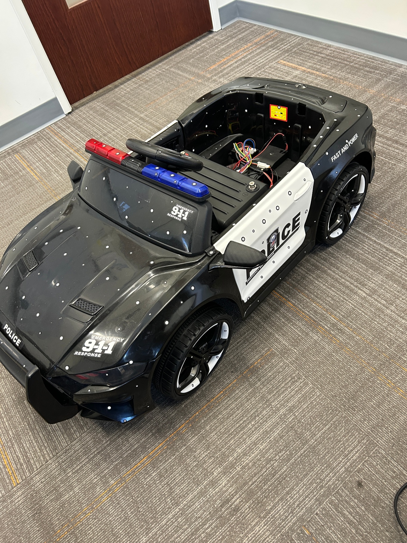
Early integration focused on solving the mechanical problems: mounting the Orbbec 360-degree sensor array for unobstructed field of view, routing power from the vehicle's electrical system to the compute module, and establishing the thermal envelope for sustained GPU inference in an enclosed space.
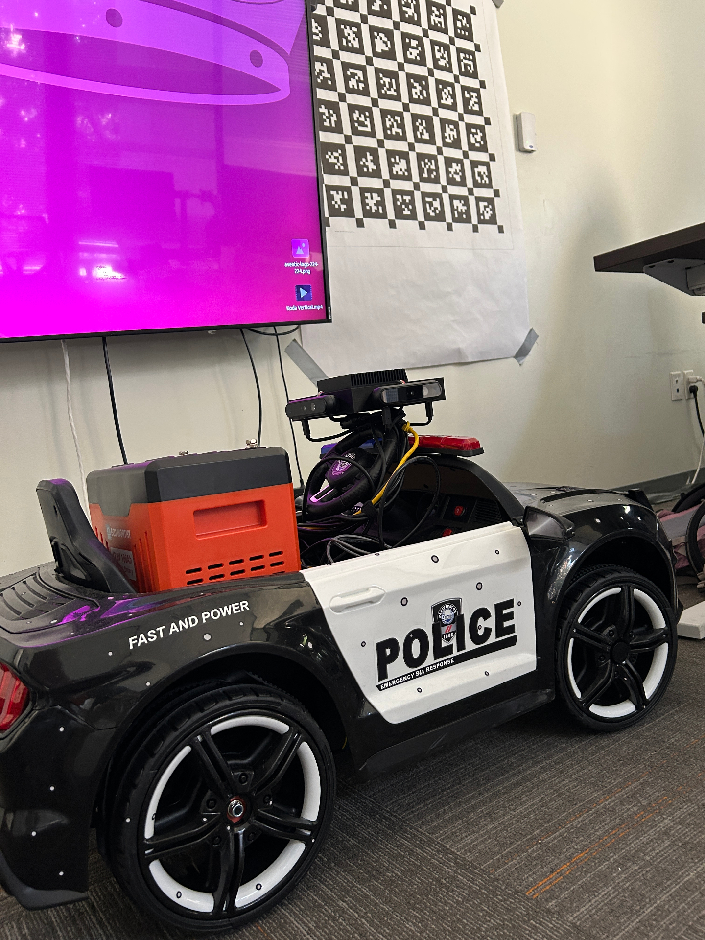
Camera calibration is a critical step before any SLAM system goes live. The checkerboard target visible in the background is used to compute the Orbbec sensor's intrinsic parameters and verify stereo alignment — ensuring the depth maps are geometrically accurate before the system starts building 3D reconstructions in the field. We use Zhang's calibration method with a 9×6 asymmetric checkerboard, capturing a minimum of 40 images across varied orientations and distances to solve for the full intrinsic matrix (focal length, principal point, and radial/tangential distortion coefficients) plus the extrinsic transform between the depth and RGB imagers.
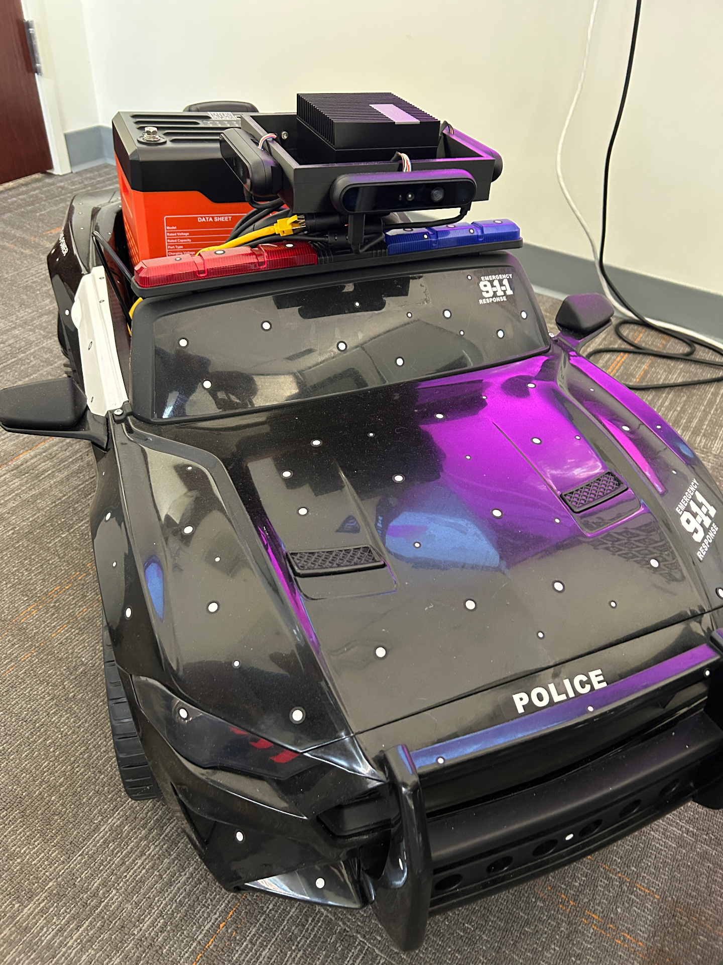
The deployed configuration mounts the Jetson Orin and Orbbec sensor in a ruggedized enclosure on the vehicle's roof, with power and data cables routed through the cabin to the trunk-mounted inference server. The entire perception stack — SLAM, segmentation, and tracking — runs on the Jetson at the edge, while the LLM inference happens on the Blackwell GPUs in the trunk.
Deployment: bringing a frontier model to the cruiser
The trunk-mounted compute module is built around two NVIDIA Blackwell GPUs running tensor parallelism. The model is served via vLLM, which provides efficient batched inference and integrates natively with the compressed-tensors format that Enfuse's quantization produces.
from vllm import LLM, SamplingParams
from transformers import AutoTokenizer

model_id = "enfuse/Qwen2.5-72B-Instruct-NVFP4"
tokenizer = AutoTokenizer.from_pretrained(model_id)

llm = LLM(model=model_id, tensor_parallel_size=2)
sampling_params = SamplingParams(temperature=0.2, top_p=0.9, max_tokens=1024)
We run the LLM inference loop asynchronously relative to the SLAM pipeline. The perception stack operates at sensor frame rates (10–30 Hz), while the LLM processes batched scene summaries at 1–3 Hz — fast enough for real-time situational awareness without bottlenecking the mapping system.
Thermal management and power architecture
Thermal management was a significant engineering challenge. Two Blackwell GPUs under sustained inference load in a vehicle trunk generate considerable heat — approximately 1,400W combined thermal design power at peak inference load. We developed a custom liquid cooling loop tied into the vehicle's climate system, with thermal throttling policies that degrade gracefully — dropping to a smaller fallback model under extreme conditions rather than shutting down inference entirely.
The cooling system uses a compact liquid-to-air heat exchanger mounted in the trunk with ducted airflow to the vehicle's exterior. Coolant (a propylene glycol/water mix rated to -40°C) circulates through cold plates mounted directly on each GPU package at 2.5 L/min, maintaining junction temperatures below 83°C at sustained load in ambient temperatures up to 45°C. Above that threshold, the system enters a tiered throttling regime:
| GPU Junction Temp | Action |
|---|---|
| < 83°C | Full inference (72B NVFP4, both GPUs) |
| 83–90°C | Reduce batch size, extend inference interval to 0.5 Hz |
| 90–95°C | Fall back to Qwen2.5-7B-Instruct (single GPU, perception-only mode) |
| > 95°C | Graceful shutdown of inference, perception stack continues on Jetson |
The power system draws from a secondary deep-cycle lithium iron phosphate (LiFePO4) battery bank installed alongside the compute module, charged via a DC-DC converter from the vehicle's alternator. This isolates the inference workload from the vehicle's primary electrical system — the cruiser's lights, radio, and MDT remain unaffected even at full GPU load. Total system power draw at peak is approximately 1,800W (GPUs + Jetson + sensors + cooling), well within the capacity of a 100 Ah LiFePO4 bank with alternator charging at idle.
Edge-to-datacenter synchronization
The cruiser's onboard system and the city datacenter maintain a bidirectional data flow that operates in two modes depending on connectivity:
Real-time mode (cellular connected): Compressed point cloud deltas (new keyframes since last sync), tracked entity updates, LLM annotations, and infrastructure detections stream continuously over a 5G/LTE connection using a custom binary protocol over QUIC. We chose QUIC over TCP for its connection migration support — when the cruiser moves between cell towers, the stream continues without re-establishing connections. Bandwidth consumption averages 8–12 Mbps upstream (primarily point cloud data) and 2–4 Mbps downstream (global map updates, cross-vehicle alerts, dispatch queries).
Batch mode (end-of-shift): If cellular connectivity is unavailable or unreliable, the system queues all data to a 2 TB NVMe drive in the trunk and uploads the full shift's data when the cruiser returns to the precinct and connects to the department's wired network. A typical 8-hour patrol shift generates 60–120 GB of compressed point cloud and annotation data.
In both modes, all data is encrypted in transit (TLS 1.3 with mutual certificate authentication) and at rest (AES-256-GCM with per-shift keys derived from the department's HSM). The encryption is non-negotiable — sensor data from law enforcement operations is evidentiary material and must maintain chain of custody from the moment of capture.
What the digital twin enables
The combination of geometric SLAM and LLM-powered semantic reasoning produces a digital twin that serves two distinct missions: officer safety and city operations.
Perimeter protection
360-degree threat awareness. The system continuously monitors the environment around the cruiser — parked or moving. When an officer is on a traffic stop or responding to a call, the digital twin tracks approaching vehicles, pedestrians, and activity behind the cruiser that falls outside the officer's line of sight. Alerts surface through the in-cabin display, not as raw camera feeds, but as semantically interpreted warnings: "Vehicle approaching from rear at high speed, no headlights."
Persistent environmental memory. As a cruiser patrols its beat, the digital twin accumulates a semantically annotated history of the environment. Changes are detected and flagged automatically — a new vehicle in a previously empty lot, a storefront that was open yesterday but closed today, foot traffic patterns that deviate from the norm.
Cross-vehicle correlation. When multiple cruisers' digital twins are stitched together on the city's SR675 V3 cluster, the system can identify patterns that no single officer would notice — the same vehicle appearing near multiple incident locations, coordinated movements across neighborhoods, or infrastructure changes that correlate with crime patterns.
City operational excellence
Infrastructure defect detection. Every patrol mile becomes an inspection mile. The vision pipeline detects and geolocates potholes, cracked sidewalks, faded lane markings, damaged guardrails, leaning utility poles, and missing or obscured signage. These observations are tagged with GPS coordinates, severity classifications, and timestamped photos — then routed directly to public works departments without requiring officers to file separate reports.
Safety hazard cataloging. Broken streetlights, malfunctioning traffic signals, obstructed crosswalks, illegal dumping, and overgrown vegetation blocking sightlines are all captured passively as the cruiser drives its regular beat. The LLM classifies each hazard by type and urgency, building a continuously updated city condition map.
Trend analysis for city planning. Over weeks and months of patrol data, the aggregated digital twin reveals patterns invisible to spot inspections: which intersections have recurring debris, which blocks see the fastest road surface degradation, where pedestrian infrastructure consistently fails. City planners get data-driven maintenance prioritization instead of complaint-driven reactive repair.
Shared capabilities
Natural-language querying. Officers and dispatchers interact with the twin through conversation, not dashboards. The 32K context window allows the model to hold an entire shift's worth of scene context in a single session, enabling questions that span hours of patrol data — whether that's "What vehicles have been parked on this block for more than 20 minutes?" or "Show me all potholes detected on Main Street this week."
Automated reporting. End-of-shift reports, incident scene documentation, evidence logs, and infrastructure condition reports can be generated directly from the digital twin's accumulated context, dramatically reducing the administrative burden on officers and eliminating manual data entry for city services.
The fog of war lifts: passively building a city-scale digital twin
There's a concept in video games that maps perfectly to what this system produces: the fog of war. In games like Civilization or StarCraft, the world starts hidden. As your units move through the environment, the fog lifts and the map fills in — terrain, resources, enemy positions, all revealed through exploration. Unexplored regions remain dark.
Now imagine that every police cruiser in a city is a unit on that map. Every patrol shift, every response call, every routine drive between precincts lifts more fog. The point clouds stitch together. The semantic annotations accumulate. Over days and weeks, the city's digital twin fills in — not from a one-time scanning vehicle with a roof-mounted LiDAR array driving every street on a schedule, but passively, continuously, as a byproduct of normal operations.
This is what Google Street View would look like if it updated in real time, understood what it was looking at, and could answer questions about what changed.
How the stitching works
Each cruiser's SLAM system produces locally consistent 3D point clouds with centimeter-level accuracy. When those clouds are uploaded to the city's datacenter — either in real time over cellular or in batch at end of shift — the Lenovo SR675 V3 cluster with NVIDIA B200 GPUs runs a global pose graph optimizer that aligns overlapping regions from different cruisers and different days. Loop closures across vehicles (cruiser A's Tuesday morning map overlapping cruiser B's Wednesday evening map of the same intersection) tighten the global consistency. This is heavy compute — exactly the kind of workload the B200's 192 GB HBM3e was designed for.
Global registration pipeline
The cross-vehicle registration problem is harder than single-vehicle loop closure because the cruisers have no shared coordinate frame and may have captured the same region hours or days apart under different lighting and weather conditions. Our pipeline handles this in three stages:
GPS-seeded coarse alignment. Each point cloud keyframe carries a GPS timestamp. We use this to identify candidate overlapping regions — any two keyframes from different cruisers whose GPS positions fall within 50 meters of each other. GPS alone is accurate to 2–5 meters in urban canyons, so this is just a seed, not a solution.
Feature-based fine alignment. Within each candidate overlap region, we extract 3D keypoints using FPFH (Fast Point Feature Histograms) descriptors on the point clouds and run RANSAC-based correspondence matching to estimate a rigid transform. If the inlier ratio exceeds 40% and the transform residual is below 5 cm RMSE, the match is accepted as a cross-vehicle loop closure and injected into the global pose graph.
Global bundle adjustment. Once all cross-vehicle constraints are added, we run a full graph optimization (g2o framework with Levenberg-Marquardt) over the combined pose graph from all cruisers. For a city with 50 active cruisers each producing ~5,000 keyframes per shift, this is a pose graph with 250,000 nodes and potentially millions of edges — a problem that takes 8–15 minutes on a single B200 using sparse Cholesky factorization, run incrementally every 30 minutes as new data arrives.
The result is a living, city-scale point cloud that grows denser and more semantically rich with every shift. Areas with high patrol density — downtown corridors, school zones, commercial districts — fill in quickly with sub-centimeter detail. Residential side streets might take longer, but they fill in too, block by block, as cruisers pass through on calls.
Navigating the twin like a video game
At the city operations center, operators can fly through the accumulated digital twin the way you'd navigate a 3D game world. Zoom into an intersection and see it as it looked at 2 AM last Tuesday — every parked car, every piece of street furniture, every crack in the pavement, all semantically labeled. Scrub the timeline forward and watch the scene evolve: cars arrive and leave, a construction barrier appears on Wednesday, a pothole that wasn't there last month shows up in this week's scans.
The unexplored regions are visible too — dark zones on the map where no cruiser has driven recently. Patrol supervisors can use this as an operational tool: routing cruisers through unmapped areas not just for coverage, but to literally fill in the city's digital twin. Patrol planning becomes map completion.
Temporal versioning and change detection
The digital twin isn't a single snapshot — it's a versioned 4D representation (3D + time). Every Gaussian splat carries a timestamp range indicating when it was observed. When a new observation of the same region arrives and the geometry or appearance has changed beyond a threshold (measured by chamfer distance on the point cloud and color delta on the splat SH coefficients), the system creates a new temporal layer rather than overwriting the old one.
This gives operators a timeline scrubber that's backed by real geometric data, not just camera footage. You can ask: "Show me this intersection as it looked last Tuesday at 2 AM vs. this Wednesday at 10 PM" and get two photorealistic 3D renderings to compare. The LLM's change detection module runs automatically, generating natural-language change reports: "New jersey barrier installed at NW corner since last observation. Two parking spots removed. Pothole at coordinates X,Y has expanded approximately 15% in area since last scan 6 days ago."
Beyond law enforcement
The implications extend well beyond policing. A continuously updated, semantically annotated 3D model of an entire city is infrastructure that every municipal department can use:
- Public works gets a living inventory of road conditions, signage, and infrastructure — updated every shift, not every fiscal year.
- Urban planning gets ground-truth data on how the built environment actually changes over time, not just how it was designed.
- Emergency management gets a current 3D model of every block for pre-incident planning, evacuation routing, and disaster response coordination.
- Utilities can cross-reference the surface-level twin with underground infrastructure maps to identify areas where surface conditions suggest subsurface problems.
- Insurance and risk assessment — commercial property insurers can license access to the twin for building condition monitoring, flood risk visualization, and claims verification without sending adjusters into the field.
- Autonomous vehicle validation — AV companies can replay the photorealistic twin as a simulation environment for testing perception and planning stacks against real-world geometry, lighting, and object distributions, without driving physical test miles.
The city doesn't commission a scanning project. The city doesn't hire a contractor. The city doesn't wait. The twin builds itself, one patrol at a time.
Privacy, governance, and the Enfuse platform
Deploying a 72B parameter model that processes street-level sensor data in a law enforcement context demands rigorous governance. This is precisely why we chose to build on the Enfuse platform, which was designed from the ground up for regulated, sovereign AI deployments.
All inference runs on-premise — on the vehicle and at the city datacenter. No sensor data, scene descriptions, or model outputs leave the department's infrastructure. The Enfuse platform provides full audit logging of every prompt and response, role-based access controls for the digital twin, and compliance tooling for evidence chain-of-custody requirements.
The model itself operates under the Qwen License, and Enfuse's quantization preserves the original model's alignment and safety properties. We additionally apply a law-enforcement-specific system prompt and output filtering layer that constrains the model's responses to operational relevance and prevents misuse.
Data retention and access control
The system implements a tiered data retention policy managed through the Enfuse platform:
| Data Type | Retention Period | Access Level |
|---|---|---|
| Raw sensor data (point clouds, RGB) | 90 days | System administrators only |
| LLM annotations and scene documents | 1 year | Authorized officers + dispatch |
| Infrastructure condition reports | Indefinite | City operations (anonymized) |
| Evidence-tagged captures | Per case disposition | Case-assigned personnel + legal |
| Gaussian splat representations | Rolling 180 days | Dispatch + city operations |
All access is authenticated via the department's existing identity provider (SAML 2.0/OIDC federation), and every query — whether from a dispatch operator navigating the twin or an officer asking a natural-language question — is logged with the requestor's identity, timestamp, query content, and response content. The audit log is append-only, stored on a separate WORM (Write Once, Read Many) volume, and tamper-evident via hash chaining.
What comes next
We are currently in field trials with two partner agencies, with plans to expand to a broader pilot in the coming quarters. Near-term development focuses on four areas:
Multimodal input. Feeding camera frames directly to the model alongside structured scene descriptions, leveraging vision-language capabilities in future model iterations. The goal is to eliminate the intermediate captioning stage entirely — the LLM sees what the camera sees, reasons about it in context, and annotates the twin directly. Early experiments with vision-language models suggest this could reduce the perception-to-annotation pipeline latency by 40% while improving annotation quality for rare or ambiguous objects that the captioning model misclassifies.
On-device fine-tuning. Adapting the model to agency-specific terminology, local geography, and operational patterns using LoRA adapters applied on top of the NVFP4 base. Each department's model would learn its own district's landmarks, common incident patterns, and reporting conventions without modifying the base weights — a 50–100 MB adapter file per agency, hot-swappable at deployment time.
Federated twin aggregation. Building city-scale digital twins from the combined patrol data of an entire fleet, with differential privacy guarantees on the aggregated model. The key challenge is enabling cross-jurisdictional twin stitching (county sheriff + city PD + state highway patrol all contribute to the same regional twin) while maintaining data sovereignty — each agency's raw data never leaves its infrastructure, only encrypted geometric features and anonymized annotations flow to the shared aggregation layer.
Audio integration. Fusing the cruiser's external microphone array with the visual digital twin to add an acoustic dimension — gunshot detection and localization, traffic noise mapping for urban planning, and ambient sound classification (construction, emergency vehicles, crowd noise) that enriches the semantic layer without adding cameras.
The fusion of frontier LLMs with classical robotics perception is still in its early days. But the trajectory is clear: the models are getting smaller, the hardware is getting faster, and the gap between raw sensor data and human-level situational understanding is closing. For law enforcement — and for any domain where autonomous systems must operate in complex, high-stakes environments — that convergence changes everything.
Built with Enfuse sovereign AI infrastructure. Model: enfuse/Qwen2.5-72B-Instruct-NVFP4 on Hugging Face.
Sponsored by

Related Resources
What Is Sovereign AI?
Complete guide to sovereign AI platforms and data sovereignty
On-Prem LLM Deployment
Hardware requirements, deployment patterns, and implementation methodology
Sovereign Compute
GPU infrastructure management for on-premises AI workloads
Air-Gapped AI Platform
Disconnected AI deployment for classified and secure environments